Mount Rainier National Park
Elev.: 1,914'
Sites: 188
Fee: $12/15a night (Advance reservations are highly recommended from June 21 - September 2. The nightly fee during that period is $15 per site; it's $12 per site during the off season, when sites are available on a first-come, first-served basis.)
Flush toilets, cold running water only in bathrooms. No showers.
If you're looking for the most beautiful campground on God's green earth, look no further than Ohanapecosh., 20 minutes north of the sleepy little burgh of Packwood, on the southwest corner of Mount Rainier National Park. This is our family favorite.
Named for a riverside
Taidnapam or “
As usual, our first
impression upon pulling into the Ohanapecosh Campground is that we've fallen
into a vast vat of verdure. The Ohana forest leaks lichen the color of cucumber
meat from absinthe cedar boughs. Salal,
bunchberry dogwood and five types of fern peek out of a lavish carpet of
clubfoot moss. Giant conifers litter the
forest like fallen behemoths. A silver
breeze rustles massive red cedar and hemlock trees, sighing sulkily
through conifers that are hundreds of years old. Sunshine skips across so many shades of
emerald that the landscape looks like Oz, especially near the
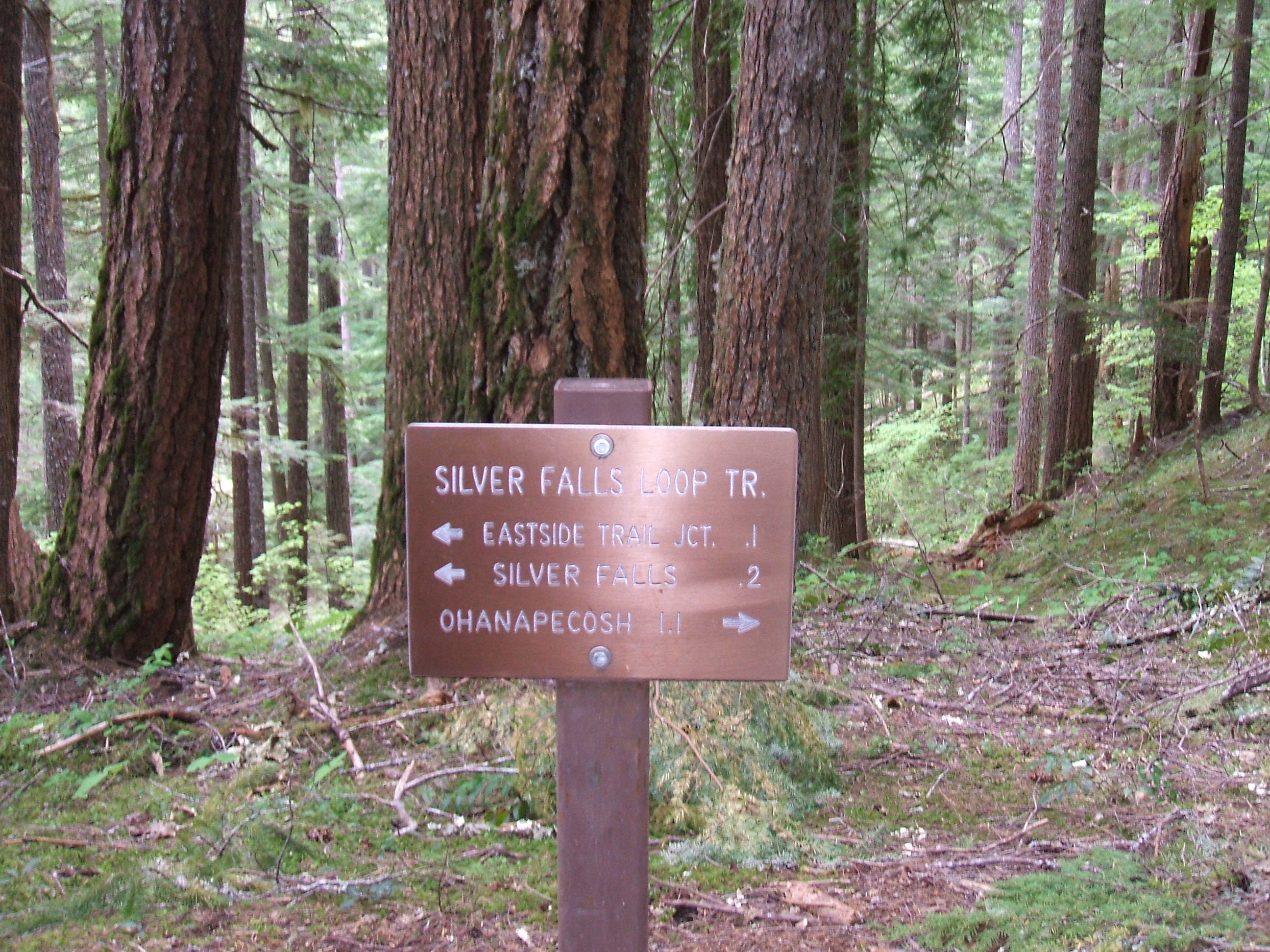
The Silver Falls Loop Trail
Rating: HD
One of the park’s most
popular trails, the
The S.F. Loop snakes
above the Ohana campground and steadily gains altitude for a mile or so through
a lush forest under achingly blue skies.
Red huckleberries and pink salmonberry blooms hem the trail which dances
to the thundering tune of the
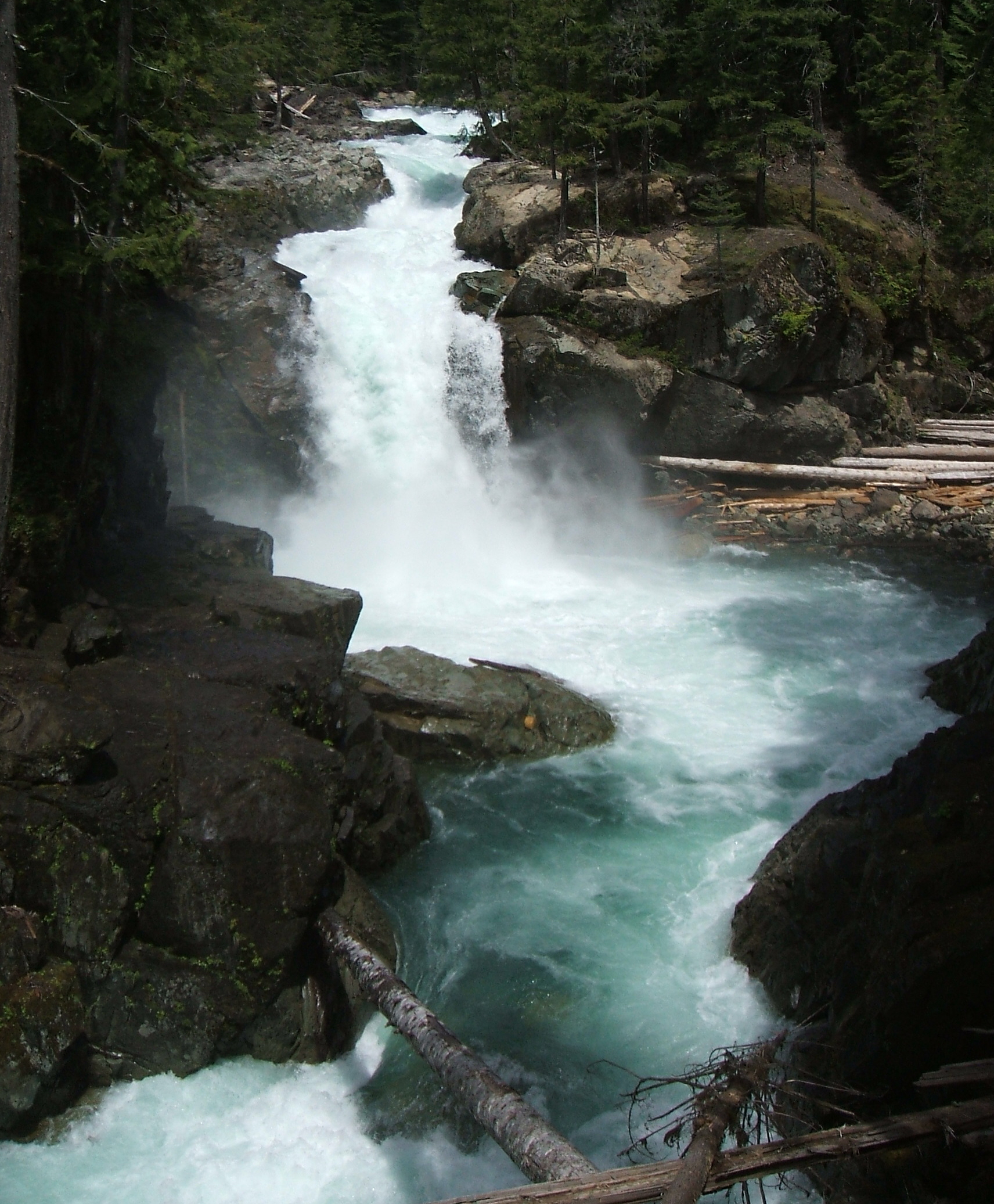
Peering over the wet, river-chiseled
rocks and moss-covered logs of the
 pur gives “tangle foot” a whole new
meaning. Recent storm damage has swept away much of the outlook and rail fence bordering the spot. Access is limited. Stepping carefully, we watch
zillions of gallons of water crash over the falls, spraying us with a fine mist
that’s as wet as rain. We’ve never seen
so much water plummeting over the falls.
We munch our trail mix and watch splinters of sunshine fracture the
mizzle into a kaleidoscope of iridescent arcs.
pur gives “tangle foot” a whole new
meaning. Recent storm damage has swept away much of the outlook and rail fence bordering the spot. Access is limited. Stepping carefully, we watch
zillions of gallons of water crash over the falls, spraying us with a fine mist
that’s as wet as rain. We’ve never seen
so much water plummeting over the falls.
We munch our trail mix and watch splinters of sunshine fracture the
mizzle into a kaleidoscope of iridescent arcs.
We can’t see The
Mountain from here but we know she’s there, towering over us like an
ermine-mantled colossus. The Queen of
the Cascades plays her well-worn game of hide and seek. She winks at us later through skies turquoise
and then pewter and then turquoise again, her ample waistline swishing above
verdant skirts.
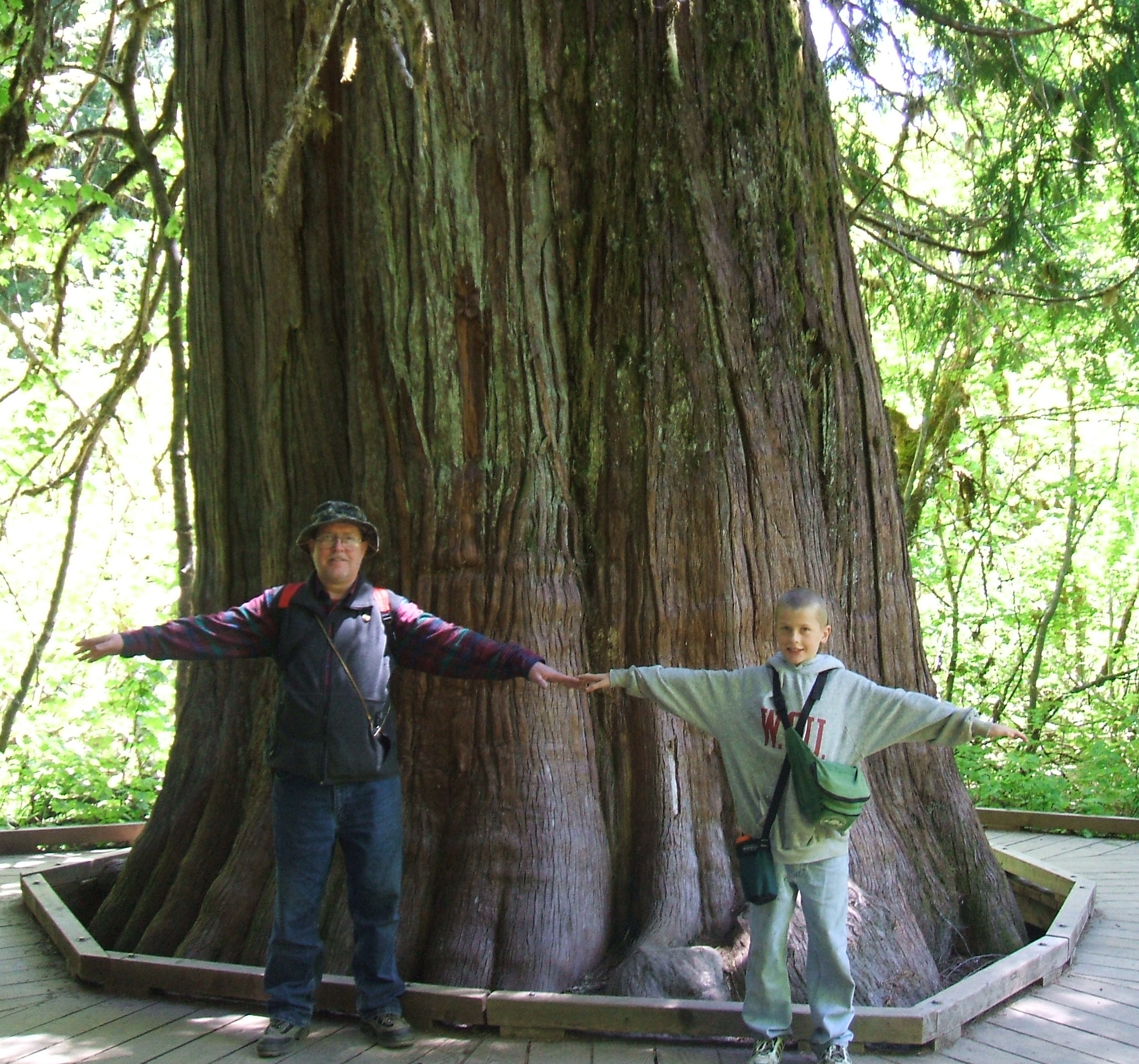 Grove of the Patriarchs
Rating: HD
From Silver Falls we continue north amid a
light rain on the Eastside Trail for a long half mile and about 250 vertical
feet. This trail curves along a
beautiful stretch of the foaming
Chugging along this lowland trail, we
encounter people of all ages, races, shapes, sizes, and ethnicities. They all have one thing in common:
reverence. You don't run on this trail.
You don't cavort or gripe. In the Grove
of the Patriarchs, you enter a green cathedral of Really Big Trees: massive
western hemlocks, western red cedars and
The massive giants like those populating The Grove of the
Patriarchs near Ohana rival the redwoods of 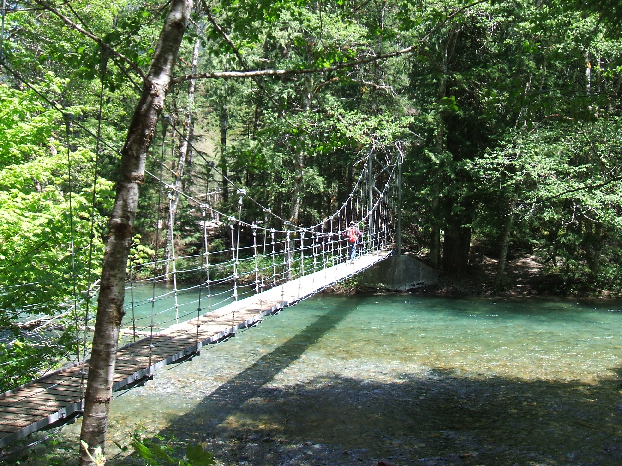 entinels within this life
zone. Some trees soar more than 200 feet
high, with diameters of ten feet or more. Several of these venerable ancients are more than five hundred years old - some over a thousand.
entinels within this life
zone. Some trees soar more than 200 feet
high, with diameters of ten feet or more. Several of these venerable ancients are more than five hundred years old - some over a thousand.
Watch where you step in the Grove. Storm damage buckled - or completely destroyed much of the boardwalk surrounding the big trees. and buried the old growth trees in a layer of silt nearly four feet deep. The suspension bridge across the Ohana River to the island where you can find the Really Big Trees (see left) was also destroyed. Repairs are underway.
Emmons Moraine Trail
Rating: J
Distance: 4.0 miles round trip
Because Paradise was socked in under
fifteen feet of snow and cold, car-wash rain the next day, we scooted over to
the
The Emmons Moraine Trail starts out of the White River Campground, just a few miles off Highway 410. This hike isn't particularly
lengthy--about four miles RT--but it's all uphill heading out. The path crosses a log footbridge over a
creek about a mile out of the
We break out the
trail mix and swig from our water bottles as afternoon sun bounces off the
blue-white snow of this icy behemoth. This view is "to die for."
"Hang-Out": Sunrise
On the thin line between
dawn and darkness,
-- Joan Walsh Anglund
The high mountain meadows of Sunrise host a riot of colorful wildflowers for a few brief weeks each summer . If you're fortunate to plan your visit to Sunrise in July or August, you'll be rewarded with acres of incredible wildflowers: blue/violet alpine asters, yellow Cinquefoils, subalpine buttercups and tiger lillies, magenta and scarelt paintbrush, rosy spirea, white valerian, bistort and beargrass - too name a few. Mount Rainier's meadows receive huge amounts of snow, giving plants a very short summer growing season. They must grow quickly and have little energy to recover from thoughtless foot-stomping, so STAY ON THE TRAILS. The Park Service estimates that with each step taken onto the meadows, an average of 20 plants are destroyed. Watch your step!
At Mount Rainier National Park, “
During our last visit in late June, daytime temperatures
hovered in the low 50s and we felt every whiff of
Mountain-washed wind as it bit cold and blue off The Mountain’s icy shoulders. Even so, there's
no better way to experience
As rangers advise, hikers
chasing the best Mountain panoramas with the least amount of sweat and blisters
select this path. The mostly level
stroll ambles onto a grand view of the Emmons Glacier and meanders through a
pristine forest of silver fir with views of The Mountain that are "to die
for."
They say that on a clear
day in midsummer you can see the ant trail of climbers ascending to The
Mountain's 14,411-foot summit. We didn't
see anyone tackling The Mountain, but it's easy to envision would-be summiteers
slogging through snow and ice to the top, where the daytime *high* was
reportedly 15 degrees F.
But don't stop at the
viewing platform. The Silver Forest
Trail continues east, following the ridge line through meadows where the narrow
dirt path is still lined by a few wildflowers not yet cowed by September's
chill. Clinging stubbornly to summer,
orange paintbrush, purple Cascade asters and frothy white Western Anemones
elbow red Mountain Heather and clumpy white Meadow Parsley for dribs and drabs
of subalpine sun.
The Mountain is omnipresent
to the south, haloed in clouds. The
Tip: If you're looking for the
best pictures of Rainier from